Defence and Space

Defence and Space

Airbus Logo

Defence and Space

Vehicle Activity National Border Case Study

Automated Monitoring of Vehicle Activity at National Border

A government agency lacks resources on the ground to detect illegal vehicle incursions along remote national border.

Vehicle activity at national border illustration case study

Challenge

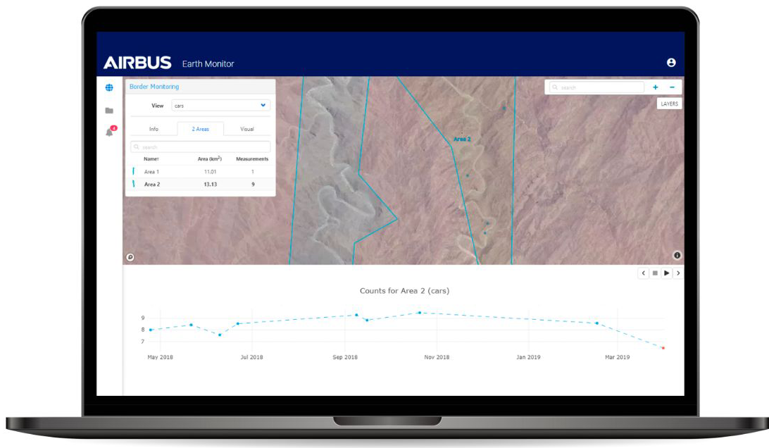
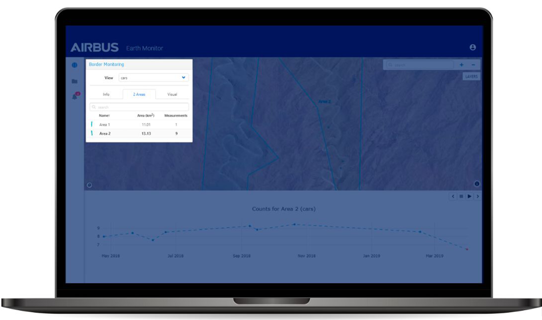
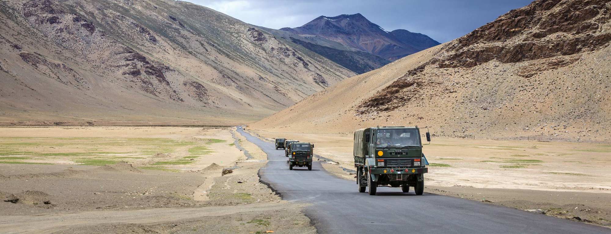
Illegal activities are taking place at the border between two nations. Hundreds of kilometres of the uncontrolled boundary snake through a remote desert region that has proved nearly impossible for one nation to defend against incursions and other illegal activities. Vehicle crossings and possible rendezvous for illicit purposes are known to occur along two 100kilometres stretches of the perimeter. 
A government agency needs detailed intelligence on activities in the region. Specifically, the agency wants to know if several potential border access tracks are used by vehicles, and where these events are taking place. With extremely limited personnel and equipment to patrol the remote region, the agency seeks another method of monitoring this illicit activity along its border.

Our solution
The service monitors the number and types of vehicles (cars trucks) along potential border access points.

How does it work?

Image 1: The OneAtlas Earth Monitor service enables detection of ongoing vehicle activity in the specified border area and monitoring of its evolution across time.

Technology

On a periodic basis, the Pléiades satellites can capture optical images of the Area of Interest at 0.5m resolution. An automated workflow is activated upon each new acquisition, and the imagery is automatically analysed using Artificial Intelligence techniques to extract the desired information for the client with precision and accuracy.

Specifications

Image 2: The automated analysis identifies vehicles differentiating cars from trucks, and maintains an ongoing count at specific border locations at the user-specified frequency.

Visualisation

Image 3: Earth Monitor determined that incursions were occurring and pinpointed their locations so the client is able to deploy resources appropriately.

Earth Monitor provides the client a statistical report detailing the total number and types of vehicles in the border-crossing area, and its temporal evolution. The analysis also shows geographically where those intrusions occurred with statistics on a time line revealing patterns of activity.

Image Mock up defence
Defence Mockup
Mock up Defence

Benefits

Locations of potential illegal activities have been identified for effective deployment of limited enforcement resources. 

The client enhanced its national security through automated monitoring of a contentious border area, which allowed the nation to safely deploy its limited resources in a targeted and cost-effective manner and establish control over its legally established boundaries.

Want to know more?

Our sales team will be happy to provide you more information about this case study and how it can meet your business needs.

satellite-image-map-airbus-product-page.jpeg

See all our case studies

See all
Muruntau Gold Mining Lifecycle
Oil, Gas, Mining and Energy
Civil Engineering and Infrastructure
Pléiades Neo

Muruntau Gold Mining Lifecycle from large-scale to Very-High Resolution

Muruntau's significance is crucial for Uzbekistan's mining industry and industrial development. Effective monitoring with satellite imagery is essential for the mining lifecycle's well-being and longevity. Being able to track global site, safety, and resource management using advanced technologies is an asset. Real-time data from large to VHR resolution will support decision-making, enhance operational efficiency, and contribute to the evolution of the Muruntau’s mine.

Dsaitek_banner.jpg
Environmental Assessment and Prediction
Pléiades Neo

Illegal dumping detection and monitoring

Disaitek has developed Illegal Waste Tracker Platform that automates the detection and monitoring of waste and illegal dumps using Pléiades and Pléiades Neo and their advanced Artificial Intelligence models.

Picture_flood.jpg
Forestry and Environment
Pléiades

Alianza Team uses Starling to Assess Peatlands and Forests Across their Palm Oil Supply Chain

In line with their goal of achievening a deforestation-free agricultural supply chain by 2025 – and in alignment with their NDPE (No Deforestation, No Peatland Expansion, and No Exploitation of People and Communities) – Alinaza Team partnered up with Starling and Earthworm Foundation to assess the current state and potential risks linked to forest and peatland conservation practices in both their current and future palm oil supply chain.